Suggested training routes in the Karkonosze — with maps, GPX tracks, distance, elevation and the huts you'll pass.
Here are our suggested training routes in the Karkonosze. We know not everyone knows these mountains as well as we or the local runners do, and you may wonder where to go to take in the most beautiful trails and places. So here are some tips!
The routes partly overlap with the ZUK course, but we also wanted to show you beautiful places in the Karkonosze that are worth a visit and aren’t on the ZUK route. These are only a few suggestions — we encourage you to explore and combine trails and variants as you like.
We deliberately don’t give times, because they depend on your pace and on trail conditions, which can change completely from one day to the next. In each description you’ll find a map, a GPX track for your watch, the exact distance and elevation, and the huts along the route.
Route 1
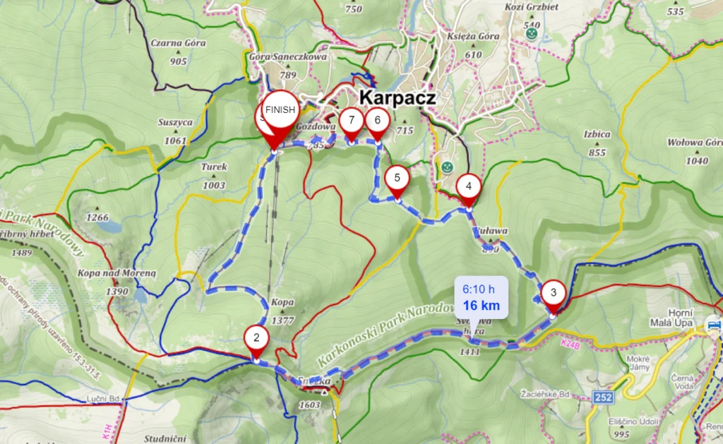
Karpacz – Śnieżka
16 km
Distance
940 m
Total ascent
960 m
Total descent
Start where the black trail leaves the lower station of the Kopa chairlift. It’s a convenient starting point, with plenty of (paid) parking nearby.
The route is essentially a climb up Śnieżka and a descent through Sowia Dolina back to Karpacz. A short, sharp, fast workout with beautiful views. It works well the other way round too.
Huts on the way: Dom Śląski (before Śnieżka), roughly halfway.
Note! The red trail (by Dom Śląski) through the Łomniczka cirque is closed in winter, so you can’t use it as a shortcut.
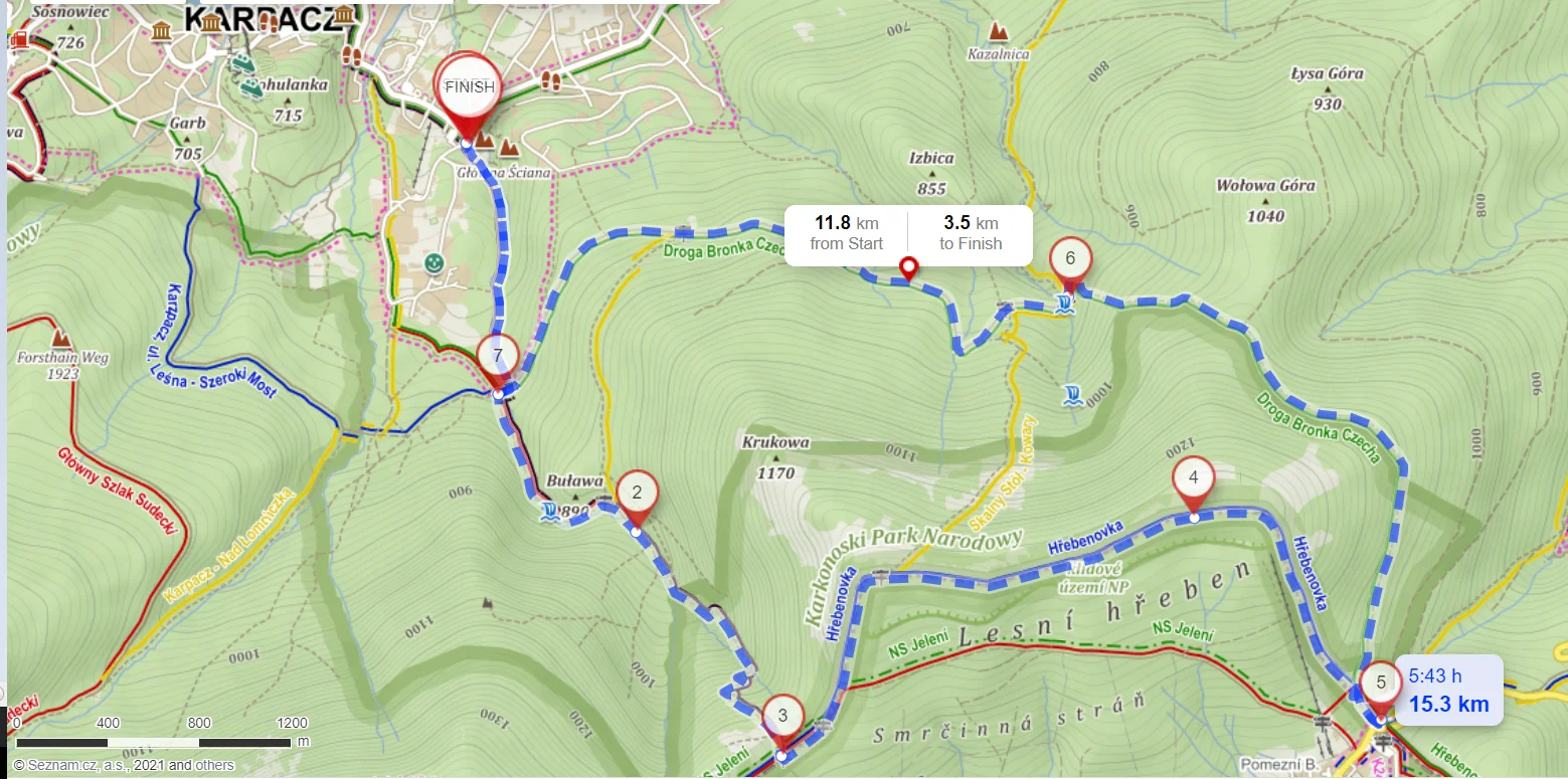
Start at the car park by Krucze Skały. It isn’t big, but it’s much quieter, so you should find a space.
After a short, easy climb, a steep slog begins up the black trail towards Sowia Przełęcz. Next comes Skalny Stół, which in good weather gives a stunning view of Śnieżka, part of the ridge and Karpacz. Then a flat, enjoyable stretch towards the Okraj Pass (it can be wet in places), finishing with a steep descent. At the pass you can stop at the “Schronisko na Przełęczy Okraj” hut, or turn right and 200 m on, already in Czechia, call in at a small local shop or the bar by the ski lift.
The way back to Karpacz is the green trail, once known as the “Tabaczana Ścieżka” and now the “Droga Bronka Czecha”. In winter it’s often narrow and barely trodden, which makes it truly charming. First gently uphill, then a lovely descent all the way to Budniki. Budniki is an old settlement of which only a few house foundations remain. It’s worth stopping to read the boards about the people who lived there, the school and the hut that once stood there. Every year Budniki held the “Welcoming of the Sun” — a ritual that let the villagers enjoy the sunlight in a valley that, because of its position, saw very little of it all year.
This is one of our favourite quick outings. There are usually very few people on it (Okraj Pass aside), so you can enjoy the views and the quiet of the Karkonosze away from the main ridge.
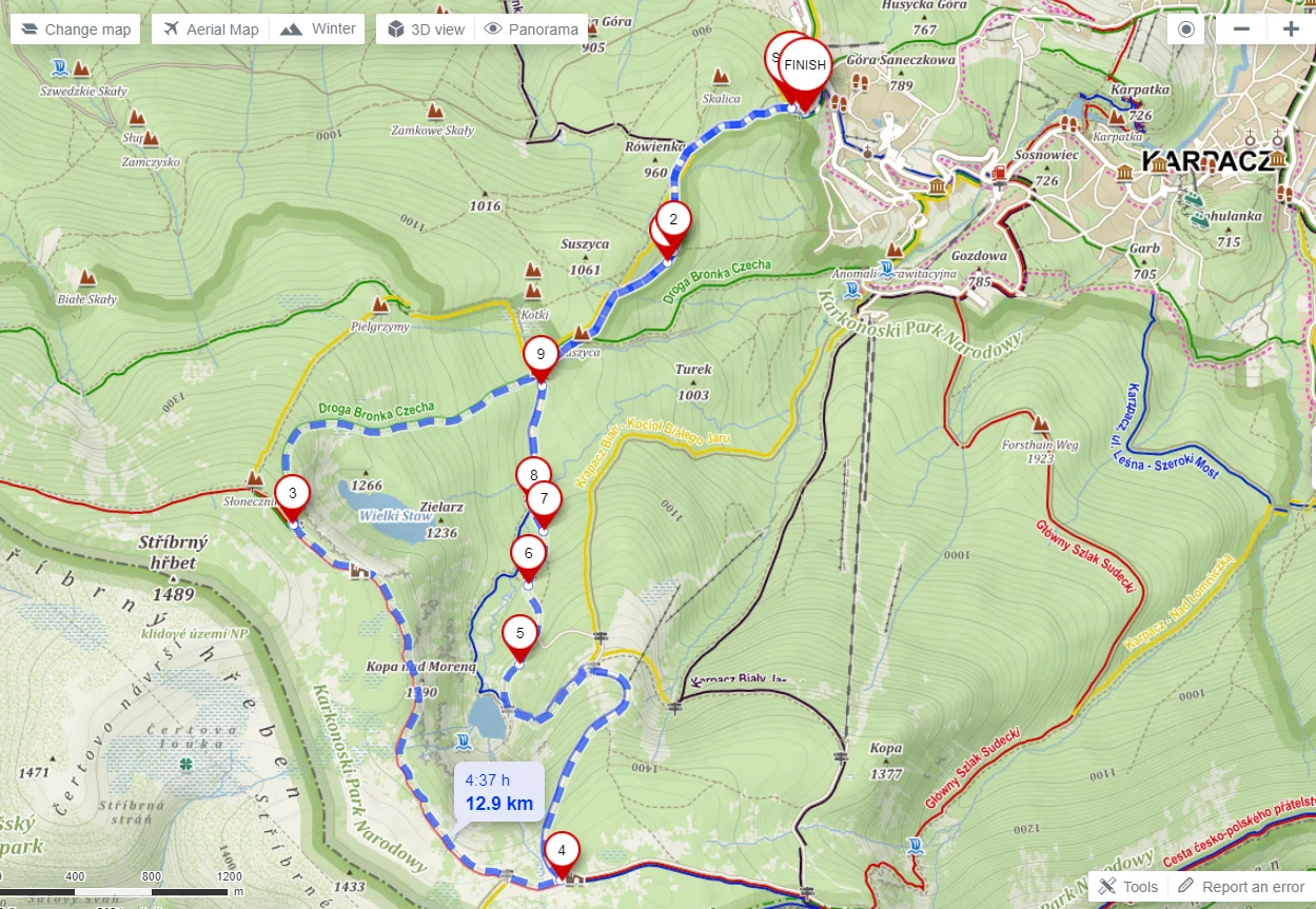
Karpacz Wang Church – Main Karkonosze ridge – Strzecha Akademicka – Samotnia
13 km
Distance
570 m
Total ascent
580 m
Total descent
Not a very demanding session, and almost the whole route can be run. You can take it two ways:
Option one: climb the green trail up to the ridge. It’s steep — for most people more of a hike than a run — but you get a longer stretch to the hut if you plan to stop there for a while.
Option two, the other way round: a steady, enjoyable (in places harder) climb all the way to the Samotnia hut, then steeply up to the ridge past the Strzecha Akademicka hut. Then a flat stretch along the ridge and a steep descent down the green trail towards the way back to the Wang Church.
If you’ve never been to Samotnia, you’ll fall for the place.
Jakuszyce – Hala Szrenicka – Szrenica – Śnieżne Kotły
23 km
Distance
840 m
Total ascent
1080 m
Total descent
The best way to do this session is to take the train from Szklarska Poręba to Jakuszyce. The ride takes barely a quarter of an hour, among cross-country skiers heading for Jakuszyce’s famous trails.
From the station head for the main road: a short way along the ski trails, or a short stretch towards the petrol station and on to Leśniczówka and the green hiking trail. In winter the green trail is especially beautiful and almost deserted. It follows a narrow path through dense forest, past Owcze Skały — interesting rock formations with views around. You reach the hut at Hala Szrenicka and carry on up towards Szrenica, where you can make a short detour into the Szrenica hut and enjoy the view over Szklarska Poręba.
Then join the red trail along the main Karkonosze ridge and run a good stretch of the ZUK course. You pass the Trzy Świnki and Twarożnik rock formations, skirt Łabski Szczyt and soon reach Śnieżne Kotły — careful, the wind there can be ferocious!
Note! The winter variant of the trail runs along the right side of Wielki Szyszak, a bit as if you were dropping to the Czech side. Stay alert so you don’t run too far into Czechia, and rejoin the trail along the border at the right moment (the winter poles won’t help much, as they also lead towards the descent into Czechia). A little further, at Przełęcz pod Śmielcem, head back along the red trail to reach the blue trail down. If you miss it, there’s another way down to the blue trail a bit further on, at Czarna Przełęcz (about 1.5 km extra).
Note! The green trail towards the Pod Łabskim Szczytem hut (below Śnieżne Kotły) is closed in winter. Run a little further to the safe red trail instead. From the hut, descend on the blue trail (turning as on the map towards the centre of Szklarska Poręba) or the yellow one — to the lower lift station and the town centre.
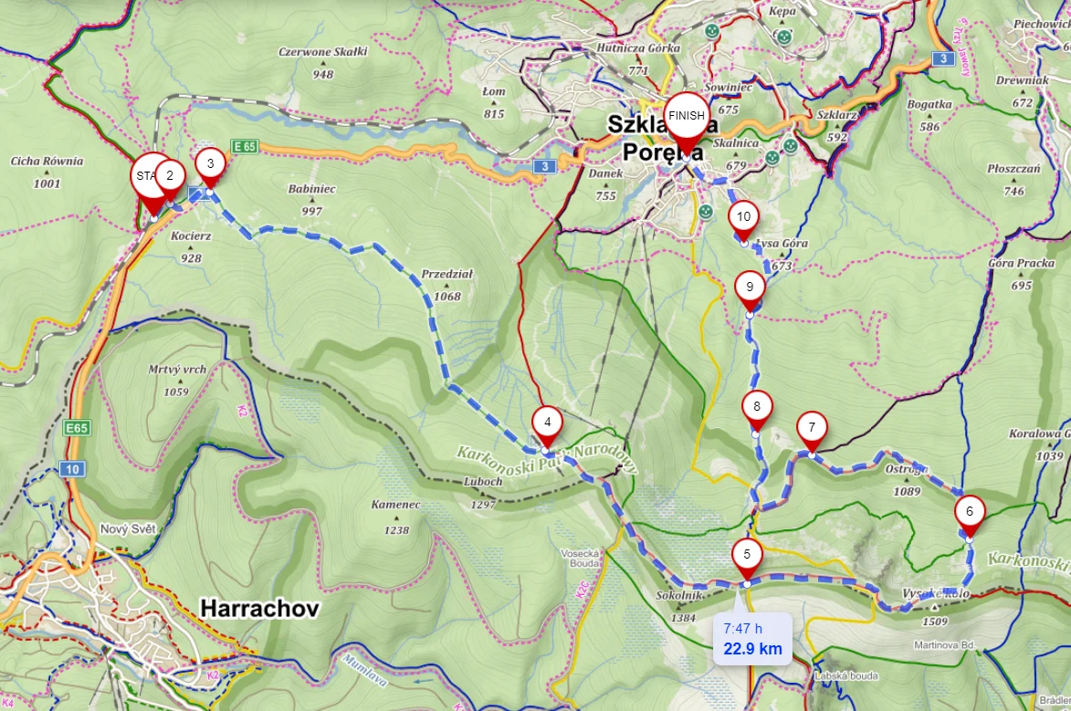
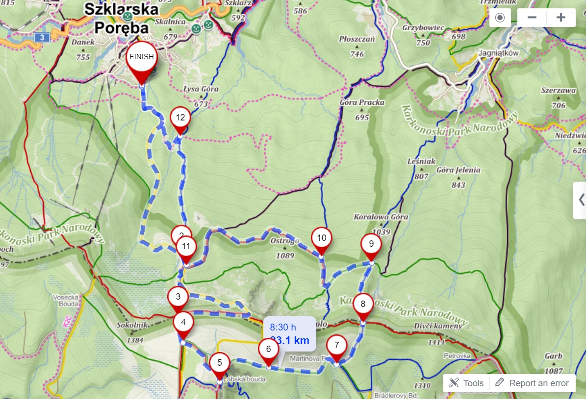
Szklarska Poręba – Czechia (Elbe Springs, Labská bouda, Martinova bouda) – Czarna Przełęcz – Pod Łabskim Szczytem hut
23 km
Distance
1200 m
Total ascent
1200 m
Total descent
A fairly demanding session — first because of the number of climbs, second because of the distance. You can shorten it a little by climbing from the hut straight up to the ridge along the official winter route marked with poles (blue trail); the Mapy.cz app won’t plot this variant.
We suggest an easy, accessible taste of the Czech side of the Karkonosze, with a quick return to the Polish side — which isn’t always that simple. Just over the border you’ll find the springs of the Elbe, then a fairly flat stretch to the Labská bouda hut and a turn onto the yellow trail, which leads down to the Elbe Waterfall with a stunning view of the river and valley. Then take the narrow, very pleasant green trail to the beautifully set Martinova bouda hut, followed by a climb back to the Polish side and a descent past the Pod Łabskim Szczytem hut (which you passed earlier) to Szklarska Poręba.
Note! The green trail from Rozdroże pod Wielkim Szyszakiem to the Pod Łabskim Szczytem hut is closed in winter. Descend lower, to the safe red trail.
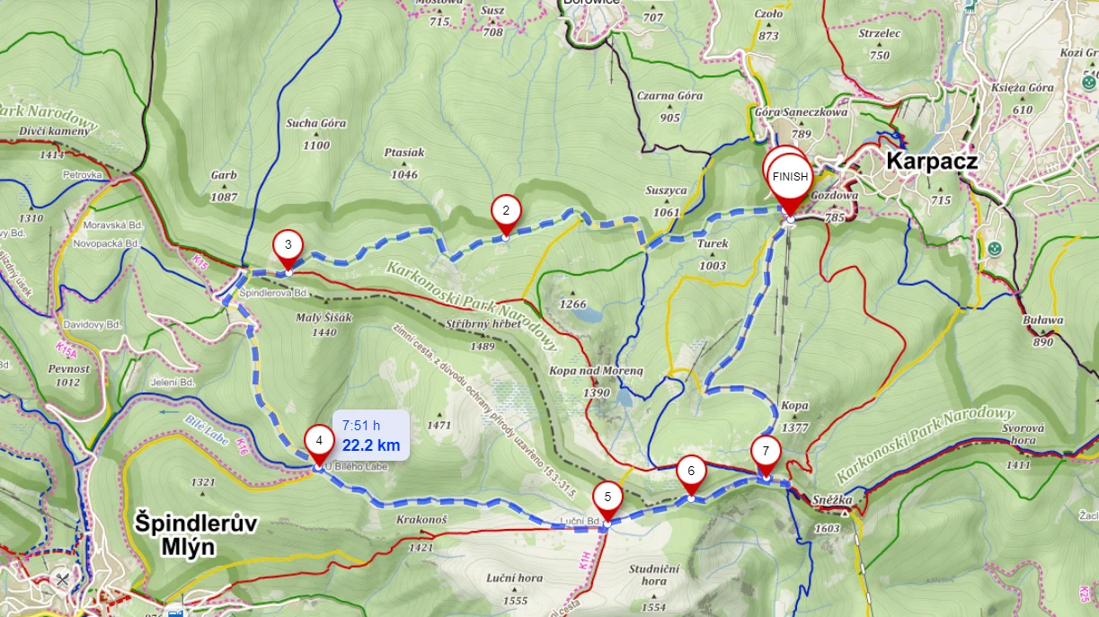
Karpacz – Odrodzenie hut – Czechia (Luční bouda, option via Krkonoš peak and Kozí hřbety) – Dom Śląski (+ Śnieżka)
23 km
Distance
1000 m
Total ascent
1000 m
Total descent
This one isn’t easy either, especially when you factor in:
the usually less-trodden green trail to Przełęcz Karkonoska,
the optional extension to Krkonoš peak with a view of Kozí hřbety,
a quick out-and-back up Śnieżka.
Allow extra time — there’ll be plenty of photos and great huts.
The route starts from the car park at the lower station of the Kopa chairlift, but instead of the more popular black or yellow trail we take the green one. It traverses nicely to Przełęcz Karkonoska and the Odrodzenie hut. Note that it can be narrow and less trodden, so it may take longer than you plan. At the border, head down into Czechia, simplest along the road. At some point the yellow trail branches left; before you reach the small settlement and the Bouda u Bílého bar, turn onto the blue trail towards Luční bouda. You’ll pass the Avalanche Waterfall and climb a pleasant path to the junction with the red trail.
If you’re keen: run just over a kilometre along the flat towards Krkonoš peak, which looks out over Kozí hřbety — the only real rocky ridge in the Karkonosze — and the Czech side of the range. A beautiful spot. Then back on the trail towards Luční bouda, with an unusual view of Śnieżka the whole way in good visibility. You reach Dom Śląski and either call it a day and run down to Karpacz (black or yellow trail — they come out at practically the same place), or add a bonus stage up Śnieżka before descending to Karpacz.
Remember that some trails in the Karkonosze are closed in winter and must not be used. This is mainly for safety and to avoid areas at high risk of avalanches. Please respect these rules — serious avalanche accidents happen in the Karkonosze every winter.
The list of closed trails and the GOPR and avalanche warnings are on the Karkonosze National Park website: kpnmab.pl/ostrzezenia